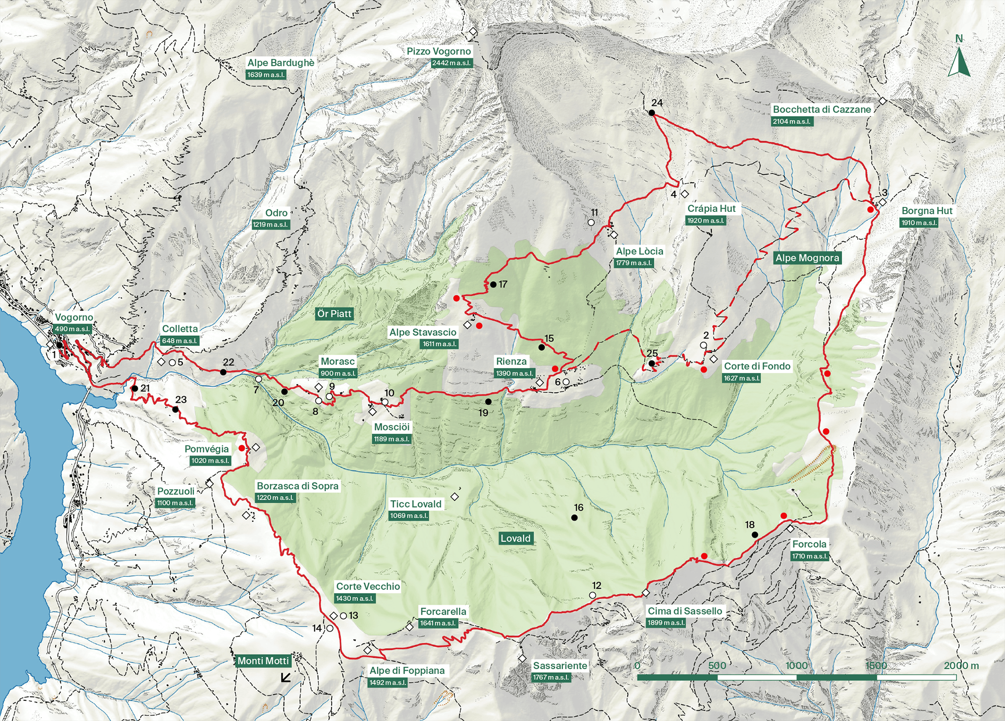
Visit the Val Porta

Visit the Val Porta

Visiting information, itineraries
and detailed map.


Visitor Information


Coordinates

2’712’500, 1’119’500
Central point


Topographic map

CNS 1:25’000
Sheet no. 1313, Bellinzona


Access point / Infopoint

Vogorno, Town Hall


Most suitable period

June - October


Equipment

Mountain equipment necessary.


Signposting

The trail network is marked with its own green signs and is indicated on the ground by yellow signs for hiking trails, white-red-white signs for mountain trails and white-blue-white for alpine trails (along the Sassello wall).


Stopover points

Borgna Hut: with kitchen, services and dormitory.
Crápia Hut: simple emergency bivouac.


Connections

Vogorno can be reached by the Val Verzasca cantonal road and is served by the postbus that departs from the Locarno SBB station, passing through the Tenero SBB station and Gordola Post Office.

Mappa valporta

© swisstopo

  • 1

    Infopoint

  • 2

    Mountain pasture

  • 3

    Borgna Hut (2’714’670 / 1’120’870)

  • 4

    Crápia Hut (2’713’450 / 1’120’960)

  • 5

    Colletta Oratory

  • 6

    Oratory of S. Antonio

  • 7

    Historic staircase

  • 8

    Spring

  • 9

    Tripod for overhanging wire

  • 10

    Spring

  • 11

    Preliminary works

  • 12

    Wall of Sassello

  • 13

    Ancient settlement

  • 14

    Charcoal burners

  • 15

    Beechwood

  • 16

    Abieti - Beech forest

  • 17

    Larch forest

  • 18

    High altitude pioneer forest

  • 19

    Birch forest

  • 20

    Alder Grove

  • 21

    Mixed deciduous forest

  • 22

    Colletta chestnut forest

  • 23

    Pomvégia chestnut forest

  • 24

    Wet biotope

  • 25

    Wet biotope

  • Forest Reserve Protected Area

  • Main path

  • Alternative trail

  • Localities

  • Place of historical and cultural interest

  • Place of naturalistic interest

  • Panoramic point